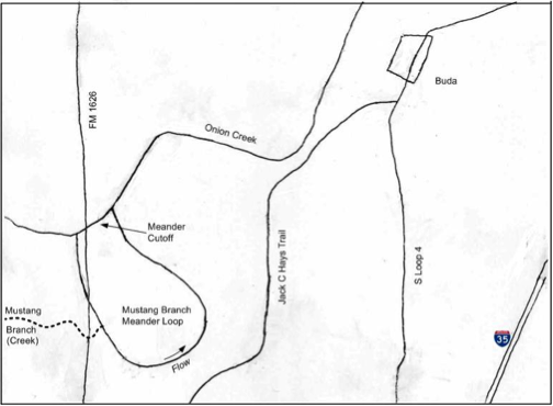
Onion Creek originates in the Texas Hill Country and flows generally eastward, joining the Colorado River southeast of Austin. Where the stream crosses the Balcones Escarpment, it displays an outstanding geomorphic feature, a prominent cutoff meander loop. It is located about two miles southwest of Buda and west of Interstate 35 (Figure 1). Texas FM 1626 crosses one leg of the loop. Although Onion Creek no longer flows through the former channel, a smaller tributary stream, Mustang Branch (also called Mustang Creek), enters and flows southward and then around the loop of the meander. The geomorphic feature is therefore named the Mustang Branch Meander Loop (MBML).
Geologic Context
The geology of the MBML reflects its location in the Balcones Escarpment between the Hill Country on the west and Gulf Coastal Plain to the east. The bedrock geology consists of Cretaceous limestone, clay and marl strata that are highly disrupted by the Balcones Fault Zone (BFZ). The general stratigraphic sequence, from oldest to youngest, is as follows: Georgetown formation (marl), Del Rio Clay, Buda limestone, Eagle Ford clay, Austin chalk (limestone), and Sprinkle clay. The Georgetown formation and Del Rio Clay are shown in Figure 2.
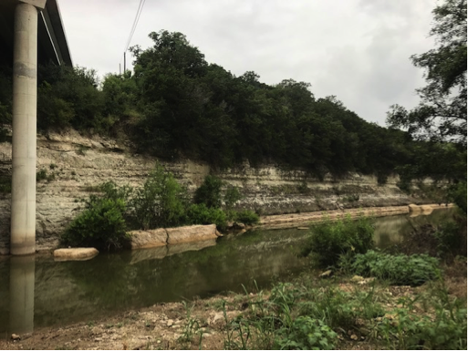
The trees above the exposure are on the overlying Del Rio clay.
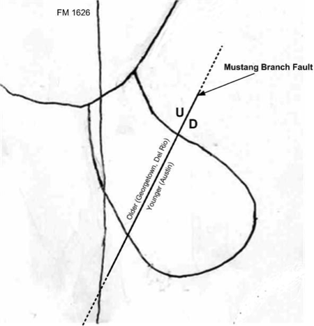
The MBML crosses a major northeast-trending BFZ fault, referred to here as the Mustang Branch fault, twice in its arcuate course (Figure 3). Younger strata of the Austin chalk on the southeast side of the fault are downfaulted against the older Georgetown formation and Del Rio clay on the northwest side. The Eagle Ford clay has not been observed and appears to be “faulted out” by the Mustang Branch fault. The Sprinkle Clay overlies the Austin chalk on the south side of the MBML.
Geomorphic Features
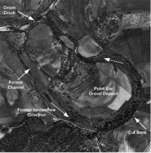
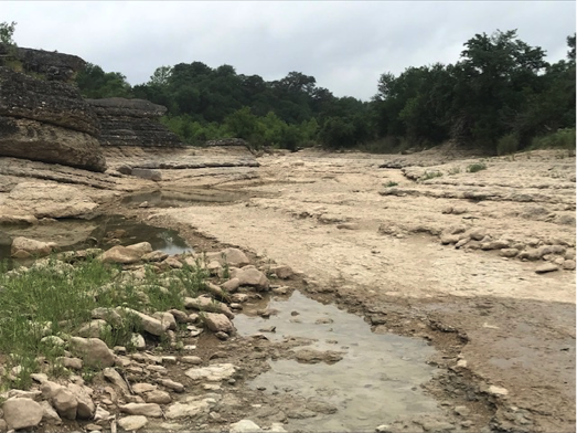
The MBML exhibits many features characteristic of a fluvial meander loop, including an abandoned channel, point bar gravel deposits, and a cut bank (Figure 4). The meander cutoff is between two parts of the former MBML channel (indicated by the “Onion Creek” label in Figure 4).
Mustang Branch is a tributary to the channel (Figure 1), as it was before the meander was cut off. Because the flow of the tributary is now much smaller than the previous Onion Creek, Mustang Branch is considered an “underfit” stream. The MBML fluvial geomorphic features were formed by the much larger Onion Creek and not by the smaller Mustang Branch.
The cut bank formed in the Austin chalk, which is resistant to erosion in the upper part and forms a cliff at the top of the bank. Since the meander was cut off, cut bank erosion has greatly diminished, and an apron of colluvium has accumulated at the base of the upper cliff. The Sprinkle clay overlies the Austin chalk at the top of the cliff. The current channel of Onion Creek is on the Georgetown formation at and around the meander cut off location (Figure 5) and is therefore an actively downcutting stream in this stretch.
The extent of downcutting since the meander cutoff – the difference in elevation of the current creek bed and the abandoned channel – has not yet been determined. Before the cutoff, the MBML was also a vigorously downcutting stream, particularly in the stretch where it crosses the Austin chalk and formed the cut bank.
Terrace Gravel
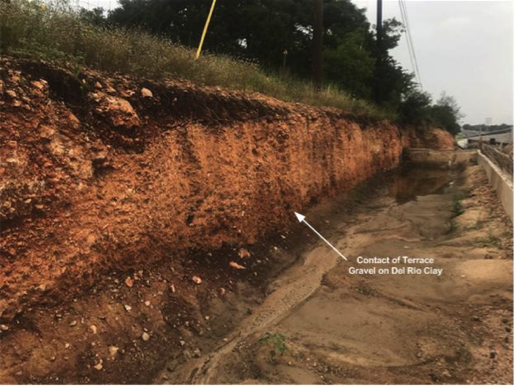
In addition to the relict geomorphic features of the MBML, there is evidence of older fluvial activity of Onion Creek. A higher-elevation terrace gravel is located on the inside of the loop adjacent to Onion Creek (Figure 6). The gravel is deposited on the Del Rio clay (Figure 7).
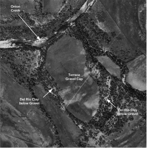
This gravel cap is no doubt a remnant of a more extensive deposit of alluvium that existed previously and has been mostly eroded away. Fluvial geomorphic features like those of the MBML are not observed in the relatively small remaining remnant. The mottled appearance of the gravel cap intimates fluvial activity, but a satisfactory interpretation is not possible.
Gravel Mining
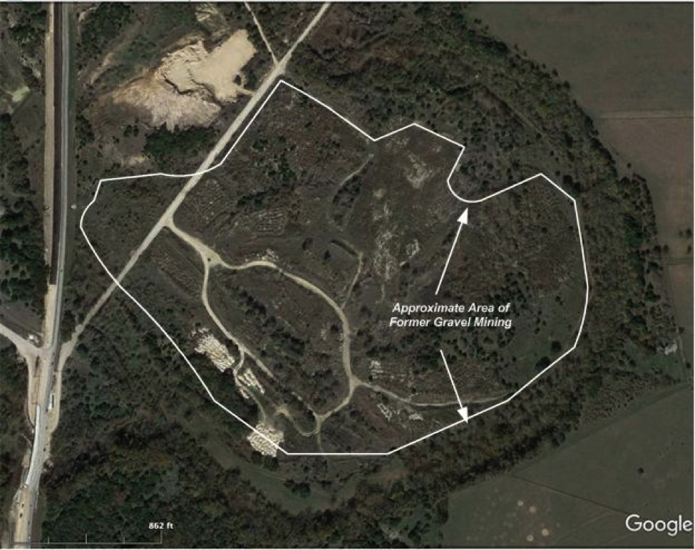
The gravels of the point bar have been mined extensively in the past (Figure 8), perhaps to the extent that the resource has been exhausted. FM 1626 can be seen on the left side of Figure 8. The bridge over Mustang Creek is in the lower left-hand corner. The mined area is based on inspection of the image and would be better delineated with field verification at some time in the future.
Geologic History
At least since the uplift of the Edwards Plateau relative to the Gulf Basin, Central Texas rivers have flowed generally to the east and southeast. Erosion in their drainage basins has removed a substantial thickness of previously deposited Cretaceous and Tertiary sedimentary layers. Onion Creek is one of the family of rivers and streams that has eroded and removed large quantities of rock from their drainage basins.
The Balcones Fault Zone formed as a result of tension along the boundary of uplift between the Edwards Plateau and the Gulf Basin. The rivers flowing east from the plateau to the basin have cut deeper into the Cretaceous layers northwest of the fault zone than to the southeast. Differential erosion of the more resistant Lower Cretaceous strata in the uplifted area than the less resistant Upper Cretaceous layers to the southeast resulted in the prominent Balcones Escarpment. Since it is located right at the edge of the escarpment, the MBML development is tied closely to the emergence of that prominent geologic geomorphic feature.
Onion Creek has removed a large quantity of Lower and Upper Cretaceous sedimentary layers from its drainage basin. It continues to be a downcutting stream up to the present. As shown by Woodruff[1], the creek formerly had a larger drainage basin before part of its flow was diverted by stream capture by the Blanco River. The existing channel, the MBML and the terrace gravel above it represent increasingly older phases of the geomorphic evolution of Onion Creek. It is possible that the MBML is inherited from a time when Onion Creek was a meandering stream before the uplift occurred and then became a relic geomorphic feature as the creek changed to a downcutting stream. Or it may have formed after the creek transitioned to a downcutting mode.
Conclusions
The MBML is an outstanding fluvial geomorphic feature of Onion Creek located at the edge of the Balcones Escarpment. It is an almost “textbook example” of a cutoff meander that was, like Onion Creek is today, a downcutting and incised part of the stream. Like the stream capture event described by Woodruff, the MBML may provide important clues to the geomorphologic evolution of the region around the Balcones Escarpment.
[1] Woodruff, C.M., 1977, Stream Piracy near the Balcones Fault Zone, Central Texas. Journal of Geology, Vol. 85, No. 4 (July, 1977), pp. 483-490.